台风卡努直扑浙江 近海将有10米狂浪
2023-07-30 <<返回首页
台风卡努直扑浙江 近海将有10米狂浪
“卡努”直扑浙江,适逢海上天文大潮,近海将有10米狂浪
今年第6号台风“卡努”(强热带风暴级)将影响浙江,强度逐渐增强。
来自浙江省海洋监测预报中心消息,到明天中午,浙江海域的海浪暂时维持轻到中浪。
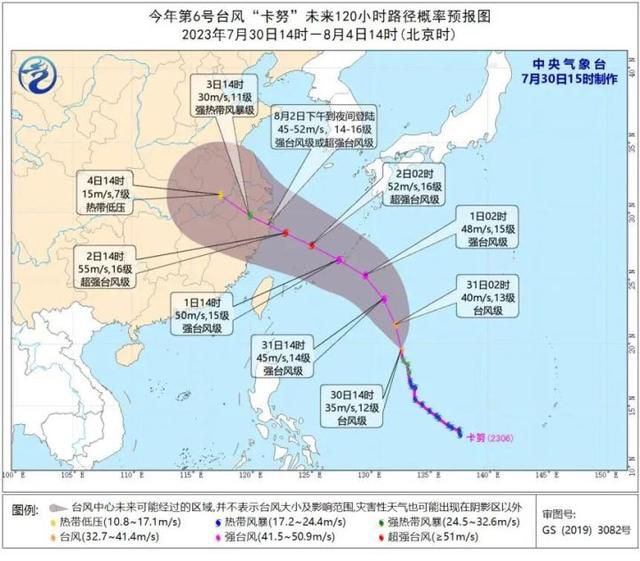
随着“卡努”的步步逼近和强度的逐渐增强,从明天(7月31日)傍晚开始,浙江海域的海浪将持续增大。明天傍晚,浙中、浙北海域将增大到2-3米的中到大浪、浙南海域将增大到2。5-3。5米的大浪,浙江所属海域风浪偏大,海上出行和滨海旅游建议暂缓。
后天(8月1日)早晨至上午,“卡努”将移入东海,并逐渐向浙江沿海靠近,届时近岸海域将有4。0-5。0米的巨浪,近海海域将有8。0-10。0米的狂浪到狂涛,海浪预警级将到达橙色。
今年第6号台风“卡努”(强热带风暴级)将影响浙江,强度逐渐增强。
来自浙江省海洋监测预报中心消息,到明天中午,浙江海域的海浪暂时维持轻到中浪。
随着“卡努”的步步逼近和强度的逐渐增强,从明天(7月31日)傍晚开始,浙江海域的海浪将持续增大。明天傍晚,浙中、浙北海域将增大到2-3米的中到大浪、浙南海域将增大到2。5-3。5米的大浪,浙江所属海域风浪偏大,海上出行和滨海旅游建议暂缓。
后天(8月1日)早晨至上午,“卡努”将移入东海,并逐渐向浙江沿海靠近,届时近岸海域将有4。0-5。0米的巨浪,近海海域将有8。0-10。0米的狂浪到狂涛,海浪预警级将到达橙色。
上一页下一页
大家都在看